Difference between revisions of "Hays County"
From Texas Century Club
Dell.Little (Talk | contribs) (→Region 5 Edwards Plateau) |
Dell.Little (Talk | contribs) |
||
| (20 intermediate revisions by one user not shown) | |||
| Line 1: | Line 1: | ||
==[[:Category:Region 5|Region 5 Edwards Plateau]]== | ==[[:Category:Region 5|Region 5 Edwards Plateau]]== | ||
| − | ''Previous county:'' ''' | + | '''Previous county:''' ''[[Haskell County|Haskell]]'', '''Next:''' ''[[Hemphill County|Hemphill]]''<br/ >'''Bordering counties:''' - '''Northeast:''' ''[[Travis County|Travis]]'', '''East:''' ''[[Caldwell County|Caldwell]]'', '''South:''' ''[[Guadalupe County|Guadalupe]]'', '''Southwest:''' ''[[Comal County|Comal]]'', '''West:''' ''[[Blanco County|Blanco]]''<br />[[File:Hays-red-Edwards Plateau.gif|380px|left]] |
| − | + | ||
| + | == Top 100 == | ||
{{#iDisplay:http://ebird.org/ebird/tx/top100?locInfo.regionType=subnational2&locInfo.regionCode=US-TX-209&year=AAAA}} | {{#iDisplay:http://ebird.org/ebird/tx/top100?locInfo.regionType=subnational2&locInfo.regionCode=US-TX-209&year=AAAA}} | ||
| + | ---- | ||
| + | |||
| + | == County Big Years & Big Days== | ||
| + | |||
| + | <span style="font-size:120%">'''[[County_Big_Years#Hays_County_-_Edwards_Plateau|Hays County Top 10 Big <span style="font-size:130%">Years]]''' | ||
| + | |||
| + | <span style="font-size:120%">'''[[County_Big_Days#Hays_County_-_Edwards_Plateau|Hays County Top 10 Big <span style="font-size:130%">Days]]''' | ||
| + | ---- | ||
==Hotspots== | ==Hotspots== | ||
{{#iDisplay:https://ebird.org/region/US-TX-209/hotspots?yr=all&m=}} | {{#iDisplay:https://ebird.org/region/US-TX-209/hotspots?yr=all&m=}} | ||
| + | |||
| + | == Guides and Resources == | ||
| + | *'''[https://birdinglocations.com/ Birding Locations.com Hot Spot details]''' | ||
| + | |||
| + | :*''[https://birdinglocations.com/aquarena-springs/ Aquarena Springs]'' | ||
| + | :*''[https://birdinglocations.com/soil-conservation-site-1/ Lake Negley/Soil Conservation Site 1]'' | ||
| + | :*''[https://birdinglocations.com/york-creek-road/ York Creek Road]'' | ||
| + | :*''[https://birdinglocations.com/spring-lake-preserve/ Spring Lake Preserve]'' | ||
| + | :*''[https://birdinglocations.com/state-fish-hatchery/ State Fish Hatchery]'' | ||
| + | :*''[https://birdinglocations.com/camp-mcculloch/ Camp McCulloch]'' | ||
| + | :*''[https://birdinglocations.com/stagecoach-park/ Stagecoach Park]'' | ||
| + | :*''[https://birdinglocations.com/lake-kyle/ Lake Kyle]'' | ||
| + | :*''[https://birdinglocations.com/schulle-canyon/ Schulle Canyon]'' | ||
| + | |||
| + | *'''[http://www.theonlinezoo.com/centraltexasbirding/ Central Texas Birding]''' | ||
| + | :*''[http://www.theonlinezoo.com/centraltexasbirding/aquarena_center.html Aquarena Center]'' | ||
| + | :*''[http://www.theonlinezoo.com/centraltexasbirding/bicentennial_park.html Bicentennial Park]'' | ||
| + | :*''[http://www.theonlinezoo.com/centraltexasbirding/schulle_canyon_park.html Schulle Canyon]'' | ||
| + | |||
| + | *'''[https://tpwd.texas.gov/huntwild/wildlife/wildlife-trails/hote Great Texas Wildlife Trails - Heart of Texas East Region]''' at Texas Parks & Wildlife | ||
| + | :*'''[https://tpwd.texas.gov/huntwild/wildlife/wildlife-trails/hote/san-marcos-loop San Marcos Loop]''' Includes: | ||
| + | ::* Garden-Ville | ||
| + | ::* Ringtail Ridge Natural Area | ||
| + | ::* Schulle Canyon Greenspace and Trail | ||
| + | ::* Purgatory Creek Natural Area | ||
| + | ::* San Marcos River Walk | ||
| + | ::* Spring Lake Preserve Natural Area/The Meadows Center for Water and the Environment, Texas State University | ||
| + | ::* Blanco Shoals Natural Area | ||
| + | ::* Five Mile Dam Park Complex | ||
| + | ::* Lake Kyle Park | ||
| + | ::* Stagecoach Park | ||
| + | ::* John J. Stokes, Sr. Park at Thompson's Islands | ||
| + | ::* CR 266 between the San Marcos River and Staples Rd. | ||
| + | ::* San Marcos National Aquatic Resource Center | ||
| + | ::* CR 234 at Southridge Estates | ||
| + | :*'''[https://tpwd.texas.gov/huntwild/wildlife/wildlife-trails/hote/wimberley-loop Wimberley Loop]''' Includes: | ||
| + | ::* Red Corral Ranch | ||
| + | ::* Jacob's Well Natural Area | ||
| + | ::* Charro Ranch Park | ||
| + | ::* Blue Hole Regional Park | ||
| + | ::* Patsy Glenn Refuge | ||
| + | :*'''[https://tpwd.texas.gov/huntwild/wildlife/wildlife-trails/hote/capitol-loop Capitol Loop]''' Includes: | ||
| + | ::* Dripping Springs Ranch Park | ||
| + | |||
| + | *Dell's map of [https://drive.google.com/open?id=19Eh_h3gtvfrd962IcY2fIqhK5jGxKSml&usp=sharing| Hays County] for birding and exploring. It includes eBird Hotspots and additional potential locations, creek crossings and roads that may be productive. | ||
| + | |||
---- | ---- | ||
| − | ''Previous county:'' '''[[Haskell County|Haskell]] | + | '''Previous county:''' ''[[Haskell County|Haskell]]'', '''Next:''' ''[[Hemphill County|Hemphill]]''<br/ >'''Bordering counties:''' - '''Northeast:''' ''[[Travis County|Travis]]'', '''East:''' ''[[Caldwell County|Caldwell]]'', '''South:''' ''[[Guadalupe County|Guadalupe]]'', '''Southwest:''' ''[[Comal County|Comal]]'', '''West:''' ''[[Blanco County|Blanco]]'' |
[[category:Region 5]] | [[category:Region 5]] | ||
[[category:All Counties]] | [[category:All Counties]] | ||
Latest revision as of 01:54, 12 December 2020
Contents |
Region 5 Edwards Plateau
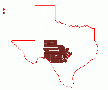
Previous county: Haskell, Next: HemphillBordering counties: - Northeast: Travis, East: Caldwell, South: Guadalupe, Southwest: Comal, West: Blanco
Top 100
County Big Years & Big Days
Hotspots
Guides and Resources
- Great Texas Wildlife Trails - Heart of Texas East Region at Texas Parks & Wildlife
- San Marcos Loop Includes:
- Garden-Ville
- Ringtail Ridge Natural Area
- Schulle Canyon Greenspace and Trail
- Purgatory Creek Natural Area
- San Marcos River Walk
- Spring Lake Preserve Natural Area/The Meadows Center for Water and the Environment, Texas State University
- Blanco Shoals Natural Area
- Five Mile Dam Park Complex
- Lake Kyle Park
- Stagecoach Park
- John J. Stokes, Sr. Park at Thompson's Islands
- CR 266 between the San Marcos River and Staples Rd.
- San Marcos National Aquatic Resource Center
- CR 234 at Southridge Estates
- Wimberley Loop Includes:
- Red Corral Ranch
- Jacob's Well Natural Area
- Charro Ranch Park
- Blue Hole Regional Park
- Patsy Glenn Refuge
- Capitol Loop Includes:
- Dripping Springs Ranch Park
- Dell's map of Hays County for birding and exploring. It includes eBird Hotspots and additional potential locations, creek crossings and roads that may be productive.
Previous county: Haskell, Next: Hemphill
Bordering counties: - Northeast: Travis, East: Caldwell, South: Guadalupe, Southwest: Comal, West: Blanco
